
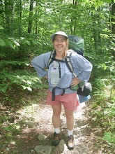
We tumbled out of the car, clicked a picture of ourselves and headed for the wide beaten path. It had been a while, and by golly, we were just happy to be out on the trail again.
“Huh," I told Tara, "they've switched to plastic trail markers." A hundred yards later the trail butted up to a chain link fence running north to south. We pulled our hats over our ears against the mid-October chill and headed north.
“This doesn’t feel right,” said
We back-tracked nearly all the way to the parking lot.
“Well there aren’t as many blazes as we’re used to, but the AT marker is plain as day,” I said.
*Note to self, never listen to me.
Frowning,
“Geez, this really is a poorly marked trail,” I complained. It was time to split up again and scout ahead at another fork in the trail.
“The trail's over here,” I hollered, finding the remnants of plastic trail sign. Just little white pieces remained pinned under large flat nail heads.
We
“We’re following the perimeter of the trail!” she said, “There’s a corridor of protected land on either side of the trail. These mark that boundary.” 
As appealing as back-tracking is, we decided to bushwhack. Logically we’d been running parallel to the real AT, if we set our course perpendicular we’d cross it.
We held our breaths... Actually we didn’t hold our breaths, but we used our eyes extra hard. In the end it worked out, we found the trail and the rest of the hike was lovely.
While retrieving the car in 
In our defense the “other trail” was bigger. We learned something though, if there aren’t white painted blazes… it ain’t the AT.
[


Informative! I plan to hike something, someday on the AT :-)
ReplyDeleteAhh, memories! I miss you and we have to get out there soon. You are so good at writing about our adventures!
ReplyDeleteNice. I feel like going on a hike again. Going back to my fast hiking experiences makes me want to get free and be wild.
ReplyDeleteAh, yes, one can never get too much of being wild and free!
ReplyDelete